Temporary Camping Closure In Place Along Portion Of North Platte River
A temporary camping prohibition, impacting dispersed overnight stays along the North Platte River on the west side of the Snowy Range, Medicine Bow-Routt National Forests, is once again in place.
A Forest Order to implement the closure, was established May 19 for public safety because of the high probability for life-threatening hazards due to post-wildfire conditions. A similar order was in place during 2021 and 2022.
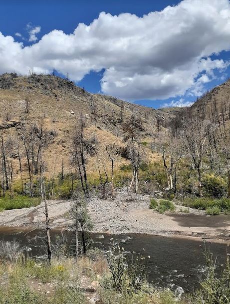
Vegetation is still re-establishing itself in drainages impacted by the 2020 Mullen Fire. There remains a high probability of flash flooding and debris flows in those drainages. Forest Service staff witnessed and documented both debris flows and flooding the last two years. Modeling and on-the-ground conditions indicate those hazards still exist in 2023. Long-duration activities in one location, such as camping, increase exposure time and therefore increase the risk associated with these activities.
“Camping immediately along the North Platte River corridor remains a safety concern,” said Brush Creek/Hayden District Ranger Jason Armbruster. “Our staff and our partners are monitoring and assessing the area, including deploying additional rain gauges in coordination with local emergency managers to increase early warning capabilities and inform decision-making.”
Effective immediately, overnight camping is prohibited on National Forest System lands within 1,000 feet of the centerline of the North Platte River, from the point the North Platte River flows across the Routt National Forest boundary immediately south of Routt Access trailhead/recreation site to the point the North Platte River flows north across the Medicine Bow National Forest boundary near the confluence with Savage Run Creek.
The affected National Forest area is in northcentral Colorado and southeast Wyoming, on lands managed by the Parks, Laramie, and Brush Creek/Hayden Ranger Districts in Jackson County, Colo.; Albany County, Wyo.; and Carbon County, Wyo.
Communication with the Wyoming Game and Fish Department has occurred, due to the impact of this camping closure to sportsmen and recreationists. Day use of the river and other associated activities such as fishing and rafting may still take place.
Forest visitors should expect to find a changed landscape when they enter the burned area, with new hazards. Specific to the North Platte River and its’ tributaries, water flows have potential to increase quickly, carrying burned debris, ash, and soil along with it. Debris, log jams, trees, and strainers, may create new obstacles and/or rapids in the river.
‘Know Before You Go’ and seek out on-the-ground condition reports before you visit. Forest Service district offices can provide information, as well as official social media pages and the Forest web site.
Information about recreation site status, maps, Burned Area Emergency Response and post-wildfire management efforts, as well as potential hazards and emergency contacts can be found on our website.
Notices, links to news articles, and additional resources are available on social media: @FS_MBRTB on Twitter or @FSMBRTB on Facebook.